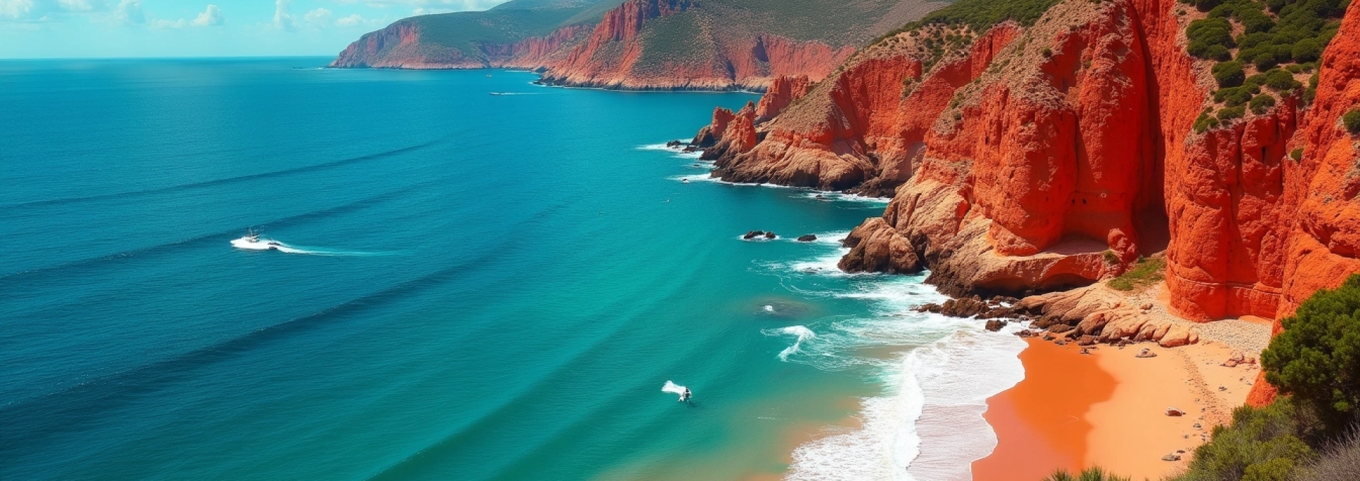
Nestled along the French Riviera between Saint-Raphaël and Cannes, the Esterel coast boasts some of the most striking landscapes in the Mediterranean. This unique stretch of coastline captivates visitors with its fiery red rhyolite cliffs dramatically plunging into crystal-clear turquoise waters. The Esterel Massif, a volcanic mountain range formed over 250 million years ago, creates a breathtaking backdrop for one of France’s most scenic coastal drives. With its rich geological history, diverse marine ecosystems, and charming coastal towns, the Esterel coast offers a perfect blend of natural beauty and cultural heritage.
Geological formation of the esterel massif
The Esterel Massif stands as a testament to the region’s tumultuous geological past. Formed during the Permian period, this ancient mountain range has withstood millennia of erosion and tectonic activity to create the stunning landscape we see today. The massif’s distinctive red hue comes from its primary rock type, rhyolite, a volcanic rock rich in silica and iron oxides.
Unlike the limestone formations common in much of Provence, the Esterel Massif’s volcanic origins have resulted in a unique ecosystem adapted to its mineral-rich soils. The area’s geological diversity not only contributes to its visual appeal but also plays a crucial role in supporting a wide variety of plant and animal species found nowhere else in France.
Volcanic origins and mineral composition
The Esterel Massif’s formation began with intense volcanic activity during the Permian period, approximately 250-280 million years ago. Massive eruptions spewed lava and ash, which cooled and solidified into the rhyolite that gives the Esterel its characteristic red color. This igneous rock is composed primarily of quartz, feldspar, and mica, with high concentrations of iron oxides responsible for its vibrant hue.
Geologists have identified several distinct phases of volcanic activity in the Esterel’s history, resulting in a complex layering of different rock types. While rhyolite dominates the landscape, basalt , andesite , and tuff can also be found throughout the massif, each contributing to the region’s rich mineral diversity.
Erosion patterns and distinctive formations
Over millions of years, wind, water, and tectonic forces have sculpted the Esterel Massif into its current form. The rhyolite’s resistance to erosion has resulted in dramatic cliffs and jagged peaks, while softer rocks have been worn away to create hidden coves and secluded beaches. This ongoing process of erosion continues to shape the coastline, with each passing year subtly altering the landscape.
One of the most striking features of the Esterel coast is the presence of dykes – vertical intrusions of igneous rock that cut through existing layers. These formations, often visible as dark bands running through the red cliffs, provide a vivid illustration of the area’s complex geological history.
Flora adaptation to rhyolitic soil
The unique mineral composition of the Esterel’s soil has led to the evolution of a highly specialized plant community. Many species have adapted to thrive in the nutrient-poor, acidic conditions created by the weathering of rhyolite. The maquis , a dense shrubland typical of Mediterranean coastal areas, dominates much of the Esterel landscape.
Notable plant species that have adapted to the Esterel’s challenging conditions include:
- Cistus albidus (white rock-rose)
- Erica arborea (tree heath)
- Arbutus unedo (strawberry tree)
- Pinus pinaster (maritime pine)
These plants have developed strategies such as deep root systems, waxy leaves to reduce water loss, and symbiotic relationships with soil fungi to survive in the harsh rhyolitic environment.
Iconic red rhyolite cliffs of cap roux
Among the most spectacular features of the Esterel coast, the red rhyolite cliffs of Cap Roux stand as a testament to the raw beauty of nature’s artistry. Rising majestically from the azure waters of the Mediterranean, these towering formations create a stunning contrast that has captivated artists, photographers, and nature enthusiasts for generations.
The cliffs of Cap Roux are not merely a visual spectacle; they also serve as a crucial habitat for numerous plant and animal species adapted to life on these vertical surfaces. Seabirds such as yellow-legged gulls and peregrine falcons nest in the crevices, while specialized plants cling tenaciously to the rock face, defying gravity and the harsh coastal conditions.
Cap roux summit panorama
For those willing to make the ascent, the summit of Cap Roux offers one of the most breathtaking panoramic views along the entire French Riviera. At 453 meters above sea level, the vantage point provides an unparalleled 360-degree vista encompassing the coastline, the Esterel Massif, and the vast expanse of the Mediterranean Sea.
On clear days, it’s possible to see as far as Corsica to the east and the Alps to the north. The interplay of light on the red cliffs throughout the day creates an ever-changing tableau, with the most spectacular displays occurring at sunrise and sunset when the rocks seem to glow from within.
The view from Cap Roux is not just a feast for the eyes; it’s a profound connection to the timeless forces that have shaped this remarkable landscape.
Turquoise waters of calanques d’or and antheor
The striking contrast between the fiery red cliffs and the crystal-clear turquoise waters is nowhere more evident than in the calanques (narrow, steep-walled inlets) of d’Or and Antheor. These hidden gems along the Esterel coast offer visitors a chance to experience some of the most pristine marine environments in the Mediterranean.
The exceptional clarity of the water in these calanques is due to a combination of factors, including the lack of major river inputs, limited human development, and the presence of Posidonia oceanica seagrass meadows, which act as natural water purifiers.
Marine biodiversity in shallow coves
The sheltered waters of Calanques d’Or and Antheor provide ideal conditions for a diverse array of marine life. The rocky shorelines and submerged boulders create a complex underwater landscape that supports a rich ecosystem. Some of the marine species commonly found in these areas include:
- Spondyliosoma cantharus (black seabream)
- Octopus vulgaris (common octopus)
- Paracentrotus lividus (purple sea urchin)
- Pinna nobilis (noble pen shell) – an endangered species
The presence of these and many other species makes the calanques a popular destination for snorkelers and divers eager to explore the underwater wonders of the Esterel coast.
Water clarity factors and visibility conditions
The exceptional water clarity in Calanques d’Or and Antheor is a result of several environmental factors working in concert. The absence of major freshwater inputs means there is little sediment to cloud the water. Additionally, the predominant northwesterly winds tend to push surface waters offshore, bringing up clearer, deeper waters to replace them.
The best visibility conditions typically occur in late spring and early autumn when water temperatures are moderate, and plankton blooms are less common. During these periods, underwater visibility can often exceed 30 meters, providing ideal conditions for observing marine life and underwater geological formations.
Snorkeling and diving hotspots
The Esterel coast offers numerous excellent snorkeling and diving locations, with Calanques d’Or and Antheor among the most popular. These sites cater to a range of experience levels, from beginners to advanced divers.
Some notable diving spots include:
- The Sec du Dattier – a submerged pinnacle teeming with fish life
- The Grotte de la Vierge – a fascinating underwater cave system
- The Pointe de l’Observatoire – known for its dramatic underwater cliffs and abundant marine life
For snorkelers, the shallow waters near the shore offer plenty of opportunities to observe colorful fish, octopuses, and the occasional sea turtle against the backdrop of the submerged red rocks.
Corniche d’or: engineering marvel and scenic route
The Corniche d’Or, also known as the Golden Corniche, is a spectacular coastal road that winds its way along the Esterel coast. This engineering marvel, completed in 1903, not only provides access to previously isolated areas but also offers one of the most breathtaking drives in Europe.
Stretching for approximately 30 kilometers between Saint-Raphaël and Cannes, the Corniche d’Or hugs the coastline, offering drivers and passengers stunning views of the red cliffs, turquoise coves, and the vast expanse of the Mediterranean Sea.
Historical construction of the coastal road
The construction of the Corniche d’Or was a monumental undertaking that began in the late 19th century. The project was initiated by the Touring Club de France, an organization dedicated to promoting tourism and improving transportation infrastructure. The road was designed to open up the rugged Esterel coast to travelers and to provide a scenic alternative to the inland route.
Engineers faced numerous challenges in carving the road out of the hard rhyolite rock. They employed innovative techniques for the time, including the use of dynamite to blast through solid rock and the construction of retaining walls to support sections of the road along steep cliffs. The road was officially inaugurated on April 11, 1903, marking a new era of accessibility for the Esterel coast.
Viewpoints and pull-offs along N98
The N98, as the Corniche d’Or is officially designated, features numerous viewpoints and pull-offs that allow travelers to safely stop and admire the spectacular scenery. Some of the most notable stops include:
- Pointe de l’Observatoire – offering panoramic views of the coastline
- Cap Roux viewpoint – providing a stunning vista of the red cliffs and azure sea
- Antheor Cove – a picturesque inlet with crystal-clear waters
These strategically placed viewpoints not only enhance the driving experience but also serve as popular spots for photography enthusiasts looking to capture the essence of the Esterel coast.
Driving challenges and safety considerations
While the Corniche d’Or offers an unforgettable driving experience, it also presents certain challenges that require attention and caution. The road features numerous sharp turns, narrow sections, and steep gradients. Drivers should be prepared for:
- Hairpin bends requiring reduced speed and careful navigation
- Sections with limited visibility around curves
- Potential rockfall in some areas, especially after heavy rains
- Heavy traffic during peak tourist seasons, particularly in July and August
It’s advisable to drive slowly, use lower gears on steep descents, and always be prepared for oncoming traffic on narrow sections. Motorcyclists should be particularly cautious, as the twisting nature of the road can be especially challenging on two wheels.
Alternative transportation: var coastal path
For those who prefer to experience the beauty of the Esterel coast at a slower pace, the Var Coastal Path ( Sentier du Littoral ) offers an excellent alternative. This hiking trail follows much of the same route as the Corniche d’Or, providing pedestrians with intimate access to the coastline and its hidden coves.
The path stretches for approximately 35 kilometers and can be divided into several manageable sections. Hikers can enjoy:
- Close-up views of the red cliffs and rock formations
- Access to secluded beaches not reachable by car
- Opportunities to observe local flora and fauna
- A more environmentally friendly way to explore the coast
While some sections of the path can be challenging, requiring good footwear and a reasonable level of fitness, the rewards in terms of scenery and tranquility are well worth the effort.
Coastal towns and hidden gems
The Esterel coast is dotted with charming coastal towns and hidden gems that offer visitors a chance to experience the region’s rich culture and history. These picturesque settlements, nestled between the red cliffs and the azure sea, provide a perfect complement to the natural beauty of the area.
Saint-raphaël’s belle époque architecture
Saint-Raphaël, located at the eastern end of the Esterel coast, is a delightful town that showcases some of the finest Belle Époque architecture in the region. The town experienced a boom during the late 19th and early 20th centuries, resulting in the construction of elegant villas, grand hotels, and ornate public buildings.
Notable examples of Belle Époque architecture in Saint-Raphaël include:
- The Casino de Saint-Raphaël, with its distinctive domed roof
- The Notre-Dame de la Victoire Basilica, featuring a mix of Romanesque and Byzantine styles
- The Villa Magali, a stunning example of Art Nouveau design
Visitors can take a self-guided walking tour to admire these architectural gems, many of which have been beautifully preserved and restored.
Théoule-sur-mer’s secluded beaches
Tucked away at the western end of the Esterel coast, Théoule-sur-Mer is a hidden gem known for its secluded beaches and tranquil atmosphere. This small village offers a more relaxed alternative to the busier resorts of the French Riviera, while still providing access to stunning coastal scenery.
Some of the most beautiful beaches in Théoule-sur-Mer include:
- Plage de la Figuerette – a small, sandy cove with calm waters
- Plage de l’Aiguille – nestled beneath dramatic red cliffs
- Plage du Suveret – a quiet pebble beach with crystal-clear water
These beaches offer visitors a chance to relax and unwind in a natural setting, away from the crowds often found in more popular coastal destinations.
Agay bay’s natural harbor and water sports
Agay Bay, with its natural harbor sheltered by the surrounding Esterel mountains, has been a haven for sailors and water sports enthusiasts for centuries. This picturesque inlet offers a range of activities for visitors looking to enjoy the Mediterranean waters.
Popular water sports in Agay Bay include:
- Sailing and windsurfing, taking advantage of the bay’s favorable winds
- Kayaking and stand-up paddleboarding along the rocky coastline
- Scuba diving and snorkeling in the clear waters around Cap Dramont
The bay is also home to a charming village with restaurants, cafes, and shops, making it an ideal spot for a day trip or a longer stay to explore the surrounding
Esterel coastline.The village is also known for its historical connection to Antoine de Saint-Exupéry, the famous French writer and aviator. Saint-Exupéry spent time in Agay and drew inspiration from the area for some of his works. Visitors can follow in his footsteps by visiting the Saint-Exupéry Memorial, which offers insights into the author’s life and his connection to this beautiful coastal region.
Conservation efforts in esterel Maritime-Terrestrial park
The Esterel Maritime-Terrestrial Park, established in 1996, plays a crucial role in preserving the unique ecosystems of the Esterel coast. This protected area encompasses both land and sea, recognizing the interconnectedness of these environments and the need for comprehensive conservation strategies.
The park covers approximately 14,000 hectares, including 10,000 hectares of land and 4,000 hectares of marine area. Its primary objectives are to protect the region’s biodiversity, maintain the ecological balance, and promote sustainable tourism practices that allow visitors to enjoy the area’s natural beauty without compromising its integrity.
Terrestrial ecosystem protection measures
The Esterel Maritime-Terrestrial Park has implemented several measures to protect the diverse terrestrial ecosystems found within its boundaries. These efforts focus on preserving native plant species, managing wildfire risks, and controlling invasive species. Some key initiatives include:
- Reforestation programs using native species adapted to the local climate and soil conditions
- Controlled burning to reduce wildfire risks and promote healthy ecosystem renewal
- Monitoring and removal of invasive plant species that threaten native biodiversity
- Creation of wildlife corridors to facilitate the movement of animals between fragmented habitats
Additionally, the park has established strict regulations on human activities within its boundaries, including limitations on construction, hunting, and off-road vehicle use. These measures help minimize human impact on sensitive ecosystems and allow natural processes to continue unimpeded.
Marine protected areas and fishing regulations
The marine component of the Esterel Maritime-Terrestrial Park is equally important in preserving the coastal ecosystem. The park has established several marine protected areas (MPAs) along the coast, which serve as sanctuaries for marine life and help maintain the health of the Mediterranean ecosystem. These MPAs feature varying levels of protection, from no-take zones to areas with regulated fishing activities.
Key marine conservation measures include:
- Strict fishing quotas and seasonal restrictions to prevent overfishing
- Prohibition of certain fishing methods that can damage seafloor habitats
- Mooring buoy systems to prevent anchor damage to sensitive seagrass meadows
- Regular monitoring of water quality and marine biodiversity
These efforts have led to noticeable improvements in marine biodiversity, with increases in fish populations and the recovery of previously degraded habitats. The success of these conservation measures demonstrates the importance of integrated land-sea management approaches in coastal areas.
Sustainable tourism initiatives
Recognizing the economic importance of tourism to the region, the Esterel Maritime-Terrestrial Park has developed a range of sustainable tourism initiatives. These programs aim to educate visitors about the area’s unique ecology while minimizing the negative impacts of tourism on the environment. Some notable initiatives include:
- Eco-friendly hiking trails with informative signage about local flora and fauna
- Guided snorkeling tours that teach visitors about marine conservation
- Environmental education programs for schools and community groups
- Promotion of low-impact activities such as kayaking and birdwatching
The park also works closely with local businesses to promote sustainable practices in the tourism industry. This includes encouraging the use of renewable energy, reducing plastic waste, and supporting local conservation efforts.
Research and monitoring programs
To inform its conservation strategies and assess the effectiveness of its efforts, the Esterel Maritime-Terrestrial Park conducts ongoing research and monitoring programs. These scientific endeavors provide valuable data on ecosystem health, species populations, and the impacts of climate change on the region.
Key research areas include:
- Long-term monitoring of indicator species such as Bonelli’s eagle and Mediterranean monk seals
- Studies on the effects of climate change on local plant and animal communities
- Assessment of water quality and marine pollution levels
- Evaluation of the effectiveness of different conservation strategies
The park collaborates with universities, research institutions, and citizen science programs to gather data and develop innovative conservation techniques. This scientific approach ensures that management decisions are based on the best available evidence and can be adapted as new information becomes available.
By combining rigorous scientific research with practical conservation measures and sustainable tourism initiatives, the Esterel Maritime-Terrestrial Park is working to preserve this unique coastal ecosystem for future generations to enjoy and study.
The conservation efforts in the Esterel Maritime-Terrestrial Park serve as a model for integrated coastal management, demonstrating how careful planning and collaboration can balance the needs of nature and human activities. As climate change and human pressures continue to impact coastal areas worldwide, the lessons learned from the Esterel coast’s conservation journey will become increasingly valuable for protecting similar ecosystems around the globe.